Running Sandbar Analyses
Before you attempt to run the sandbar analysis you should read and follow the instructions laid out on the sandbar analysis configuring page. There is also a video at the bottom of this page that demonstrates the steps described on this page.
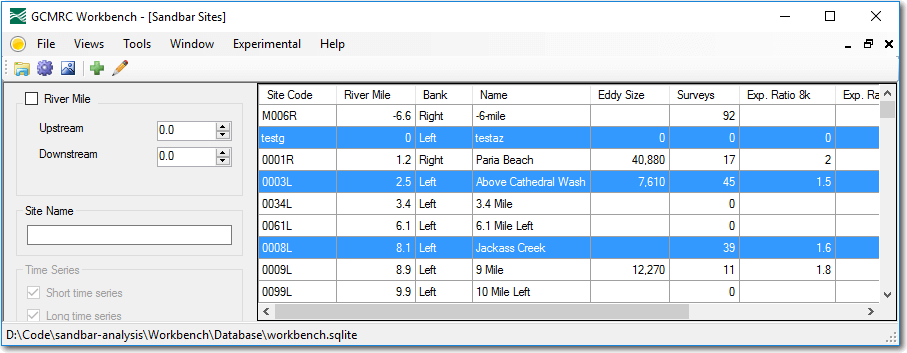
Selecting Sandbar Sites
The first step in performing the sandbar analysis is selecting the sandbar sites on which the analysis is to be performed.
- Open the workbench
- Open the
Sandbar Sitesview from the mainViewsmenu. - Select the desired sites. Use the filtering controls to narrow in on the desired sites or use one of the following shortcuts:
- All sites can be selected quickly using
CTRL+A. - A continuous set of sites can be selected by clicking on the first site and then holding down the
SHIFTkey while clicking on the last site in the list. - A discontinuous set of sites can be selected by holding down the
CTRLkey and clicking the mouse on each site.
- All sites can be selected quickly using
Configuring the Analysis
With the desired sites selected, choose Sandbar Analysis from the Tools menu.
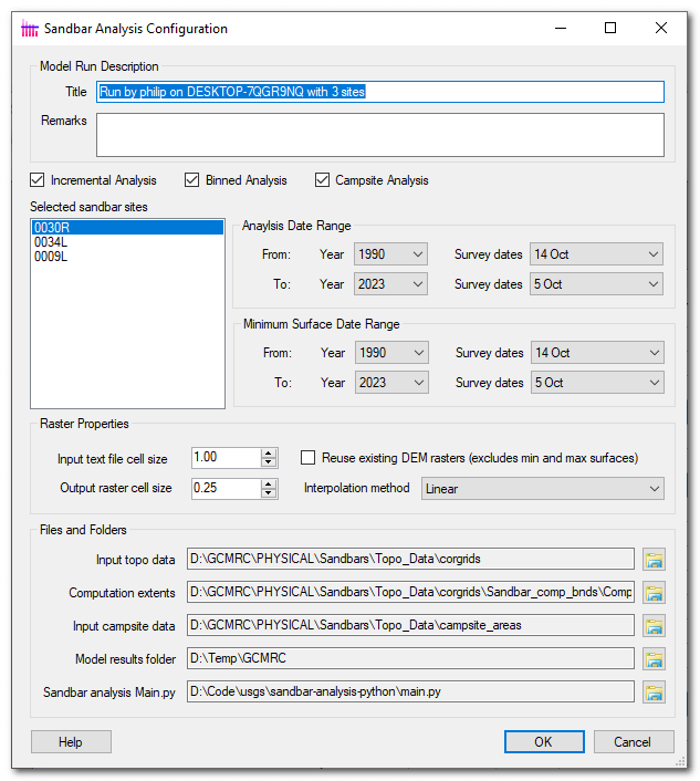
- Provide a title for the analysis. This should be as descriptive as possible and capture the intent of each particular run. Good examples summarize the parameters used or the motivation of performing the analysis.
- Remarks capture more verbose information about the run. They are optional.
- Pick one of the three types of analysis - incremental, binned or campsite that you want to perform.
- The list of selected sites simply summarizes which sites will be included. This control is not editable and the rows selected not relevant. It merely repeats the site selection that was made back on the main grid view.
- Analysis Date Range - pick the start and end date for which surveys should be included in the analysis. The individual controls contain the specific dates of surveys for all the selected sites. This date range applies to all sites. See below for further explanation.
- Minimum Surface Date Range - pick the start and end date for which surveys will be included in the minimum surface calculation for each site. The individual controls contain the specific dates of surveys for all the selected sites. This date range applies to all sites. See below for further explanation.
- Input Cell Size - specify the point spacing of the input raw text files. This should typically be left at 1m to reflect the spacing of the GCMRC grid text files.
- Output cell size - determines the cell size, in meters, of the rasters generated by the analysis.
- If the input and output cell sizes are different then an interpolation method can be selected that controls how the input data are resampled to the resolution of the output rasters.
- Checking the reuse rasters box will attempt to reuse any DEMs that already exist on the current computer from previous runs. The minimum and maximum surface rasters will never get reused and will always be regenerated with each run. Unchecking the reuse rasters box will force all DEMs to be regenerated every model run.
- Configure the file and folder paths at the bottom of the form according to the sandbar analysis configuration instructions.
Several of these parameters rarely change between runs. Use the Sandbar Analysis tab on the Options form To set the default values that are used to populate the form each time that it is used.
Analysis and Minimum Surface Date Ranges
The sandbar analysis has been configured to allow the user the filter which surveys are included in the analysis and/or the minimum surface. The analysis date range applies to all sites and specifies which surveys are actually analyzed during the model run. The minimum surface date range, as the name suggests, controls which surveys are included in the generation of the raster that represents the minimum surface. These two date ranges are specified separately so that a subset of rasters can be analyzed or included in the minimum surface. For example, this might be useful if you want to analyze all survey years but only use surveys from a specific year onward as part of the minimum surface. Conversely, you might want to just analyze a single year but still include all surveys in the minimum surface so as to retain consistency across analyzes.